
Short canoe trips near Saskatoon
Here's a handful of 1-3 day paddling trips not too far from Saskatoon. This list is by no means comprehensive - just some suggestions that we have enjoyed ourselves. Some are round trips and some require shuttles, but all are fairly simple to organize. Most of these trips are suitable for all experience levels.
Please remember paddling times are very subjective and depend on numerous factors such as fitness, ability, wind, and current. The times here are to be used as guidelines. They are roughly based on paddling speeds of 5km/hr on flatwater and 7km/hr in current. Also be aware that forested areas north of Saskatoon may have burned in the fires of 2015.
If you are interested in doing a trip let us know - we have maps here and can give you more details on route, access, conditions, campsites, booby traps, etc... :)
Day trips
South Saskatchewan River - Pike Lake Pumphouse to Saskatoon
Distance: 42km (~6hrs paddling time)
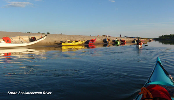
When the river is low there are great sandbars along this route. It's a fun, relaxing day trip in to town and is easiest if you can get someone to drop you off at the put-in so you don't have to shuttle at the end. The put-in is a little steep, and you have to get around a fence to get to the river.
To get to the Pike Lake Pump Station, drive south on Valley Road. Turn south onto Highway 60 and head 11.5km to where it curves into Pike Lake Provincial Park. Turn right at this point onto O'Malley Road, drive 1.8km, then take the first left along the south edge of the park. Drive east 5km to the launch. It is a dirt road so it may be mucky after it rains.
The best places to take out in the city are the Victoria Boathouse (there's a dock here), Gabriel Dumont Park, or Rotary Park. They each have parking lots where you can leave your vehicle during the day.
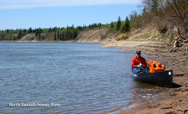
North Saskatchewan River – Borden Bridge to Petrofka Bridge
Distance: 45km (~6.5hrs paddling time)

The appeal of this trip is that it is so close to the city. Borden Bridge is only 45km from Saskatoon. The river here braids around numerous sandbars and mud flats and a number of vegetated islands, so there are good stopping spots for lunch if the water level is not high. In high water years most of the sand is underwater and you'll find the shore mucky in many places but there are still some good spots for having a land break.
Check the river discharge before you go. This trip is suitable for all levels of paddlers unless the water is very high in which case there can be swirling eddies.
Waskesiu River
Distance: 24km (~4hrs paddling time)

This is a scenic, meandering paddle with some faster Class 1 sections and a few beaver dams to keep things interesting. It's fairly shallow so check with the Park on water levels before you go. The river is banked with mixed forest and there is lots of wildlife in the area.
The put-in is at the bridge and picnic area where the highway north of the townsite of Waskesiu crosses the river. The pull-out (you'll need to do a shuttle for this one) is at the bridge where Highway 2 to La Ronge crosses the river. There is a little parking area off the highway to leave your vehicle here.
Montreal River
Distance: 33km (~4-5hrs paddling time)
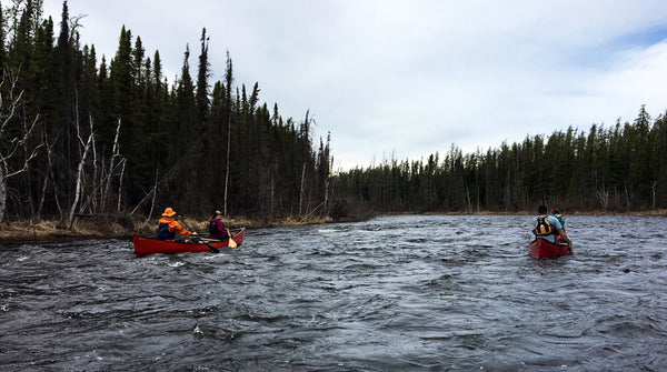
This trip is best in spring when the water level is highest. Check levels before you go in case there isn't enough water in the river. This is a really fun, moderately technical run of Class I-III whitewater that requires some skill in a boat.
Put in at the picnic site on the west side of the road where Highway 2 to La Ronge crosses the river. This is about 36km north of Weyakwin. You will paddle downstream (generally north) to the take out at the bridge on route 165.
Two-three day trips
Ducker Lake route
Distance: 35km

You can do this route in a day if you like to push the pace, but it's a great overnight trip. If you want to extend it to two nights you can explore the falls around Eyinew Island on Otter Lake on Day 2 and camp somewhere there, returning to Missinipe the next day.
The route starts and ends at Missinipe on Otter Lake, where you can leave your vehicle.
There are only three portages, the longest of which is about 365m. There are a couple of nice campsites on Ducker Lake with good swimming access and some exposed Canadian shield. Look out for the pictographs along the short Stewart River section after Ducker Lake.
Stanley to Nistowiak
Distance: 30km
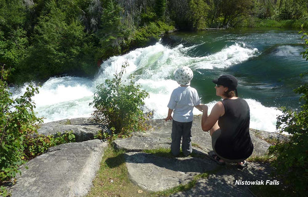
A classic and well traveled trip, this starts and ends at Stanley Mission townsite and takes you to Nistowiak Falls, one of the largest falls in Saskatchewan. There is only one portage (not including the hike up to the top of Nistowiak) and it's got rollers on a boardwalk so you don't even need to take your gear out of the canoe. Great for beginners.
Often people camp 2 nights in the same spot and use the day in between to make the trip to the Falls. There is lots of camping on Drope Lake and particularly nice spots near Big and Little Stanley Rapids, where you can fall asleep to the soothing sound of whitewater. One thing to be aware of however: this is a well traveled route so you'll get motorboat traffic
On your way out, check out the Stanley Mission Church, a historic site and worth a visit. It's always interesting to check out the guest book - people come from all over to this area.
Waterhen River
Distance: ~50km

This is an easy 2-3 day paddle in the Meadow Lakes area and suitable for most paddlers. Most of it is flatwater paddling with some Class I-II sections. Being shallow you may need to get out and wade sections in low water years.
Camping is excellent along the way; there are numerous established sites along the Boreal Trail which runs parallel to the Waterhen in sections. There are also many informal camping opportunities so it is not a problem finding a spot to lay low for the night. (Jeff's note: the blueberries are wonderful in early August.)
The put-in is at the bridge north of Goodsoil, just east of Lac des Isles. The take-out is at the bridge north of Dorintosh on Highway 4.
McLennan Lake Loop
Distance: ~45km
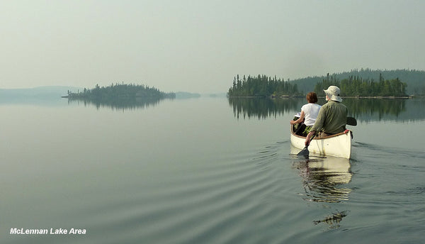
The area around McLennan Lake is gorgeous with rocky campsites and fantastic swimming. It's about 50km north of Missinipe so it's a bit of a drive, but you get right up into the Boreal Shield country. There are a number of options for paddle routes. A great 3 day trip starts at McLennan Lake and does a loop through McLean, Versailles, and Davis Lakes back to McLennan.
The nice part about this area is you don't need to shuttle. You can sometimes leave a vehicle at Bears Camp for a small fee, or you can leave your vehicle in Missinipe and pay Ric Driediger at Churchill River Canoe Outfitters for a drop-off and pick-up.
Amisk Lake
Distance: ~48km
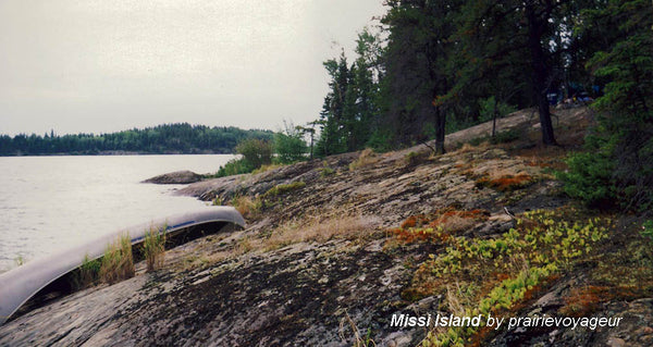
No portages on this trip, and it's a loop so no shuttling. You start and end at Denare Beach which is a cute little resort town with a public beach and campgrounds, about 6 hours from Saskatoon.
Basically you circle Missi Island which takes 2 to 3 days. It's a beautiful area with a lot of little islands so make sure you take a map and GPS - it's easy to get turned around. The only area to worry about is the southwest part of the island, where you can get some exposure to wind. Try to travel this part of the route when the weather is good, or in the early morning before the wind blows up.
There are multiple options for side trips, including checking out some interesting limestone rock formations at the south end of Amisk Lake, so don't limit yourself if you have the time.
Bagwa Route
Distance: ~25km for Bagwa loop, ~33km including North End
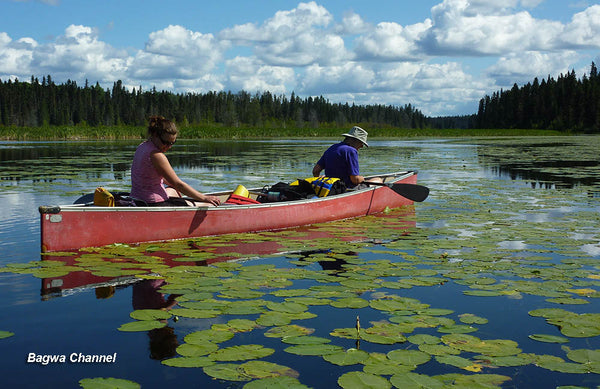
A classic trip in Prince Albert National Park that takes you through a short chain of lakes and across Kingsmere Lake. You can include a hike up to Grey Owl's cabin on Lake Ajawaan if you like as well - just camp at North End on Kingsmere Lake and take a day trip from there.
Take Kingsmere Road west along the north shore of Waskesiu Lake. It ends at the Kingsmere River which is your put-in. You'll paddle up the river a few hundred metres to a well traveled portage (about 800m long) which has steel carts on rails for transporting your gear. This takes you to Kingsmere Lake.
Most people travel in a clockwise direction, portaging into Clare Lake, then Lily Lake, then paddling through Bagwa Lake and through the Bagwa Channel to Kingsmere. There are etablished campsites on Lily and Bagwa and at Pease Point when you enter Kingsmere again.
The portage into Clare is notoriously mucky. Just bear with it, it's part of the experience. If you like fishing, Bagwa is an excellent place for pickerel.
Once back on Kingsmere, you can opt to head back to where your vehicle is or you can head to the north end of the lake and camp at a beautiful beachy campsite called - surprisingly - North End. From here you can hike to Grey Owl's cabin on Lake Ajawaan, a pleasant 3km trek through the woods.
South Saskatchewan River - Outlook to Saskatoon
Distance: ~100km
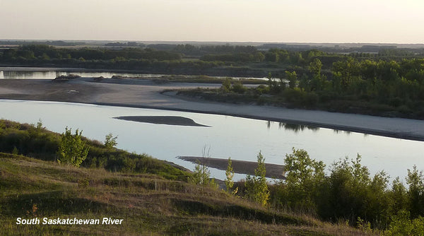
People usually take 2-3 days to do this trip, depending on how much they want to paddle each day. In lower water years there is lots of camping but it will take you longer as the river channel meanders more and there are large shallow sections to avoid. The valley is scenic and sandy with good bird watching and sometimes spectacular sunsets.
Put in at Outlook Regional Park on the east side of the river just upstream of the railway bridge. You can take out at any of the good locations in Saskatoon: the Victoria Boathouse, Gabriel Dumont Park, or Rotary Park.
North Saskatchewan River - Cecil Ferry to Gronlid Bridge
Distance: ~ 100km
This part of the North Saskatchewan River is a little more dramatic than farther west near Prince Albert. There are no rapids but the banks are steeper and you get sections of Class I water which makes it fun. The whole trip takes 2-3 days but you can extend it to Cadet Lake by Nipawin if you wish (this adds another 35km or so).
To get to the put-in drive east of Prince Albert on Highway 302 and turn north to Cecil Ferry. Once in the water you will paddle about 35km before you reach the Forks (where the South Saskatchewan and the North Saskatchewan meet). There are hardly any islands, but quite a few places to camp. Your take-out is at Gronlid Bridge, the one that crosses the river by Wapiti Valley Ski Resort.
Other areas:
There are other great areas to paddle within driving distance of the city. The Churchill River north of La Ronge is a paddler's playground. There are fun rapids, portages, scenic narrow sections and larger lakes with great camping. Jeff recommends Crean Lake in Prince Albert National Park for kayaking. There are numerous other areas and loops to paddle - check out the documented canoe routes by Saskatchewan Environment, which has detailed descriptions of many trips.
Happy paddling!
Comments
Leave a comment